


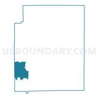
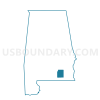
Perry's Store, Coffee County, Alabama
About
Outline

Summary
| Unique Area Identifier | 521438 |
| Name | Perry's Store |
| County | Coffee County |
| State | Alabama |
| Area (square miles) | 22.49 |
| Land Area (square miles) | 22.32 |
| Water Area (square miles) | 0.17 |
| % of Land Area | 99.24 |
| % of Water Area | 0.76 |
| Latitude of the Internal Point | 31.30083970 |
| Longtitude of the Internal Point | -86.17112860 |
Maps

Graphs
Select a template below for downloading or customizing gragh for Perry's Store, Coffee County, Alabama


Neighbors
Neighoring Voting District (by Name) Neighboring Voting District on the Map
- Basin, Coffee County, AL
- Ino Community, Coffee County, AL
- Kinston, Coffee County, AL
- Opp, Covington County, AL
Top 10 Neighboring County Subdivision (by Population) Neighboring County Subdivision on the Map
- Opp CCD, Covington County, AL (9,607)
- Elba CCD, Coffee County, AL (6,710)
- Goodman CCD, Coffee County, AL (2,286)
- Kinston CCD, Coffee County, AL (1,561)
Top 10 Neighboring Unified School District (by Population) Neighboring Unified School District on the Map
Top 10 Neighboring State Legislative District Lower Chamber (by Population) Neighboring State Legislative District Lower Chamber on the Map
Top 10 Neighboring State Legislative District Upper Chamber (by Population) Neighboring State Legislative District Upper Chamber on the Map
Top 10 Neighboring 111th Congressional District (by Population) Neighboring 111th Congressional District on the Map
Top 10 Neighboring Census Tract (by Population) Neighboring Census Tract on the Map
- Census Tract 105, Coffee County, AL (4,558)
- Census Tract 9624, Covington County, AL (3,144)
- Census Tract 107, Coffee County, AL (2,286)
- Census Tract 106, Coffee County, AL (1,561)